Skotoussa
Σκοτούσσα | |
|---|---|
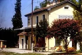 Skotoussa train station | |
 Skotoussa Location within the regional unit  | |
| Coordinates: 41°08′N 23°23′E / 41.133°N 23.383°E | |
| Country | Greece |
| Administrative region | Central Macedonia |
| Regional unit | Serres |
| Municipality | Irakleia |
| • Municipal unit | 99.4 km2 (38.4 sq mi) |
| Population (2021) | |
| • Municipal unit | 5,135 |
| • Municipal unit density | 52/km2 (130/sq mi) |
| Community | |
| • Population | 795 (2021) |
| Time zone | UTC+2 (EET) |
| • Summer (DST) | UTC+3 (EEST) |
| Vehicle registration | ΕΡ |
Skotoussa (Greek: Σκοτούσσα, Medieval Greek: Προσάνικον, romanized: Prosanikon) is a village and a former municipality in the Serres regional unit, Greece. Population 5,135 (2011). Since the 2011 local government reform it is part of the municipality Irakleia, of which it is a municipal unit.[1] The municipal unit has an area of 99.433 km2.[2]
Transport
Rail transport
The settlement is served by Skotoussa railway station on the Thessaloniki-Alexandroupoli line, with daily services to Thessaloniki and Alexandroupolis.
References
- ↑ "ΦΕΚ B 1292/2010, Kallikratis reform municipalities" (in Greek). Government Gazette.
- ↑ "Population & housing census 2001 (incl. area and average elevation)" (PDF) (in Greek). National Statistical Service of Greece.
This article is issued from Wikipedia. The text is licensed under Creative Commons - Attribution - Sharealike. Additional terms may apply for the media files.