Sarralbe | |
|---|---|
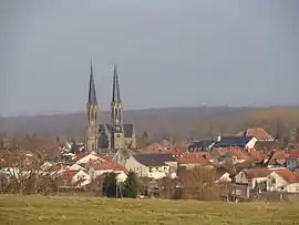 A general view of Sarralbe | |
 Coat of arms | |
Location of Sarralbe | |
 Sarralbe  Sarralbe | |
| Coordinates: 49°00′N 7°02′E / 49.00°N 7.03°E | |
| Country | France |
| Region | Grand Est |
| Department | Moselle |
| Arrondissement | Sarreguemines |
| Canton | Sarralbe |
| Intercommunality | CA Sarreguemines Confluences |
| Government | |
| • Mayor (2020–2026) | Pierre-Jean Didiot[1] |
| Area 1 | 27.29 km2 (10.54 sq mi) |
| Population | 4,392 |
| • Density | 160/km2 (420/sq mi) |
| Time zone | UTC+01:00 (CET) |
| • Summer (DST) | UTC+02:00 (CEST) |
| INSEE/Postal code | 57628 /57430 |
| Elevation | 206–262 m (676–860 ft) (avg. 210 m or 690 ft) |
| 1 French Land Register data, which excludes lakes, ponds, glaciers > 1 km2 (0.386 sq mi or 247 acres) and river estuaries. | |
Sarralbe (French pronunciation: [saʁalb]; German: Saaralben; Lorraine Franconian: Alwe or Saaralwe) is a commune in the Moselle department in Grand Est in north-eastern France.
Population
| Year | Pop. | ±% p.a. |
|---|---|---|
| 1968 | 4,366 | — |
| 1975 | 4,600 | +0.75% |
| 1982 | 4,553 | −0.15% |
| 1990 | 4,487 | −0.18% |
| 1999 | 4,538 | +0.13% |
| 2007 | 4,613 | +0.21% |
| 2012 | 4,572 | −0.18% |
| 2017 | 4,555 | −0.07% |
| Source: INSEE[3] | ||
See also
References
- ↑ "Répertoire national des élus: les maires" (in French). data.gouv.fr, Plateforme ouverte des données publiques françaises. 13 September 2022.
- ↑ "Populations légales 2021". The National Institute of Statistics and Economic Studies. 28 December 2023.
- ↑ Population en historique depuis 1968, INSEE
External links
Wikimedia Commons has media related to Sarralbe.
This article is issued from Wikipedia. The text is licensed under Creative Commons - Attribution - Sharealike. Additional terms may apply for the media files.