Leichhardt Highway | |
|---|---|
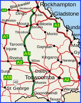 | |
| Leichhardt Highway (green on black) | |
| General information | |
| Type | Highway |
| Length | 611 km (380 mi) |
| Route number(s) |
|
| Former route number | |
| Major junctions | |
| South end | |
| |
| North end | |
| Location(s) | |
| Major settlements | Moonie, Miles, Guluguba, Wandoan, Taroom, Theodore, Banana, Dululu |
| Highway system | |
The Leichhardt Highway is a major transport route in Queensland, Australia. It is a continuation northward from Goondiwindi of the Newell Highway, via a 2.0-kilometre (1.2 mi) section of the Cunningham Highway.[1]
It runs northward from Goondiwindi for more than 600 kilometres until its termination at the Capricorn Highway near the small town of Westwood.[2]
The highway is a state-controlled strategic road, except for the section concurrent with the Gore Highway, which is a state-controlled part of the National Network.[3]
History
It is named after Prussian explorer Ludwig Leichhardt who travelled a route in the 19th century that roughly parallels today's highway.
Upgrade
A project to replace the Banana Creek bridge, at a cost of $7.7 million, was completed in April 2022.[4]
List of towns along the Leichhardt Highway
Travelling from south to north:
Major intersections
| LGA | Location | km | mi | Destinations | Notes |
|---|---|---|---|---|---|
| Goondiwindi | Goondiwindi | 0 | 0.0 | south – Queensland – NSW border | Southern end of Leichhardt Highway.[5] Runs west (as Boundary Road) then north as State Highway A5. Southern concurrency terminus with Gore Highway. |
| 4.0 | 2.5 | Leichhardt Highway turns north | |||
| 19.0 | 11.8 | Northern concurrency terminus with Gore Highway. | |||
| Western Downs | Moonie | 97.3 | 60.5 | south–west – St George | |
| The Gums | 144 | 89 | west – Surat | ||
| Condamine | 189 | 117 | |||
| Miles | 225 | 140 | west - Roma | South-eastern concurrency terminus with Warrego Highway | |
| 226 | 140 | North-western concurrency terminus with Warrego Highway | |||
| Banana | Taroom | 372 | 231 | ||
| Theodore | 449 | 279 | |||
| Banana | 506 | 314 | north – Banana CBD | Southern concurrency terminus with Dawson Highway | |
| 507 | 315 | Northern concurrency terminus with Dawson Highway | |||
| Dululu | 586 | 364 | south–east – Jambin | ||
| Westwood | 611 | 380 | south–west – Duaringa | Northern end of Leichhardt Highway | |
1.000 mi = 1.609 km; 1.000 km = 0.621 mi
| |||||
Gallery
 Leichhardt Highway, looking south from Guluguba Cafe, 2014
See also
References
- ↑ Queensland Government - Department of Transport and Main Roads - Maps
- ↑ Hema, Maps (2007). Australia Road and 4WD Atlas (Map). Eight Mile Plains Queensland: Hema Maps. pp. 8/11. ISBN 978-1-86500-456-3.
- ↑ The State Road Network of Queensland (PDF) (Map). Queensland Government. 30 June 2019. Archived (PDF) from the original on 30 March 2014. Retrieved 10 August 2021.
- ↑ "Leichhardt Highway (Westwood - Taroom), Banana Creek, replace bridge". Queensland Government. 7 April 2022. Retrieved 12 July 2022.
- ↑ Border District 5 Map Page 1 Goondiwindi Environs (PDF) (Map). Department of Transport and Main Roads. August 2007. Retrieved 31 August 2021.