| Cipunagara River | |
|---|---|
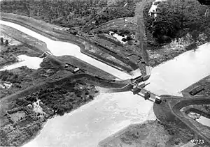 The Cipunagara River dam, utilized for irrigation in the agricultural areas around Subang and Indramayu. | |
| Location | |
| Country | Indonesia |
| Province | West Java |
| Physical characteristics | |
| 2nd source | Bukit Tunggul |
| • location | Subang |
| • coordinates | 6°48′29″S 107°43′39″E / 6.808000°S 107.727583°E |
| • elevation | 2,100 metres (6,900 ft) |
| Mouth | Java Sea |
• location | Pusakanagara |
• coordinates | 6°11′29″S 107°53′27″E / 6.191361°S 107.890722°E |
| Length | 147 km |
| Basin size | 1,360 km2 (530 sq mi) |
| Basin features | |
| River system | Cipunagara basin |
| Waterbodies | Sadawarna dam |
Cipunagara is a prominent river located in the Subang Regency of West Java, Indonesia. With a length of 147 kilometers, it traverses the region from its source in the Bukit Tunggul mountains, situated to the south of Subang Regency, the river flows in a south-to-north direction, making its way from the southern hills of Subang through various landscapes, ultimately reaching its estuary in Pusakanagara, where it meets the Java Sea.[1][2]
References
- ↑ "Peta Interaktif". WebGIS MenLHK (in Indonesian). Retrieved 2023-10-09.
- ↑ antaranews.com. "Sadawarna Dam to reduce flooding risk in Cipunagara River: Ministry". Antara News. Retrieved 2023-11-21.
This article is issued from Wikipedia. The text is licensed under Creative Commons - Attribution - Sharealike. Additional terms may apply for the media files.