Blaufelden | |
|---|---|
 Coat of arms | |
Location of Blaufelden within Schwäbisch Hall district  | |
 Blaufelden 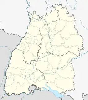 Blaufelden | |
| Coordinates: 49°17′49″N 09°58′19″E / 49.29694°N 9.97194°E | |
| Country | Germany |
| State | Baden-Württemberg |
| Admin. region | Stuttgart |
| District | Schwäbisch Hall |
| Government | |
| • Mayor (2015–23) | Petra Weber[1] (Ind.) |
| Area | |
| • Total | 90.18 km2 (34.82 sq mi) |
| Elevation | 460 m (1,510 ft) |
| Population (2021-12-31)[2] | |
| • Total | 5,303 |
| • Density | 59/km2 (150/sq mi) |
| Time zone | UTC+01:00 (CET) |
| • Summer (DST) | UTC+02:00 (CEST) |
| Postal codes | 74572 |
| Dialling codes | 07953 |
| Vehicle registration | SHA |
| Website | www.blaufelden.de |
Blaufelden is a municipality in the district of Schwäbisch Hall in Baden-Württemberg in Germany.
The settlement is first mentioned in a document from 1157. The Reformation was introduced to Blaufelden in 1526 and it has been Lutheran ever since.
References
- ↑ Aktuelle Wahlergebnisse, Staatsanzeiger, accessed 14 September 2021.
- ↑ "Bevölkerung nach Nationalität und Geschlecht am 31. Dezember 2021" [Population by nationality and sex as of December 31, 2021] (CSV) (in German). Statistisches Landesamt Baden-Württemberg. June 2022.
This article is issued from Wikipedia. The text is licensed under Creative Commons - Attribution - Sharealike. Additional terms may apply for the media files.